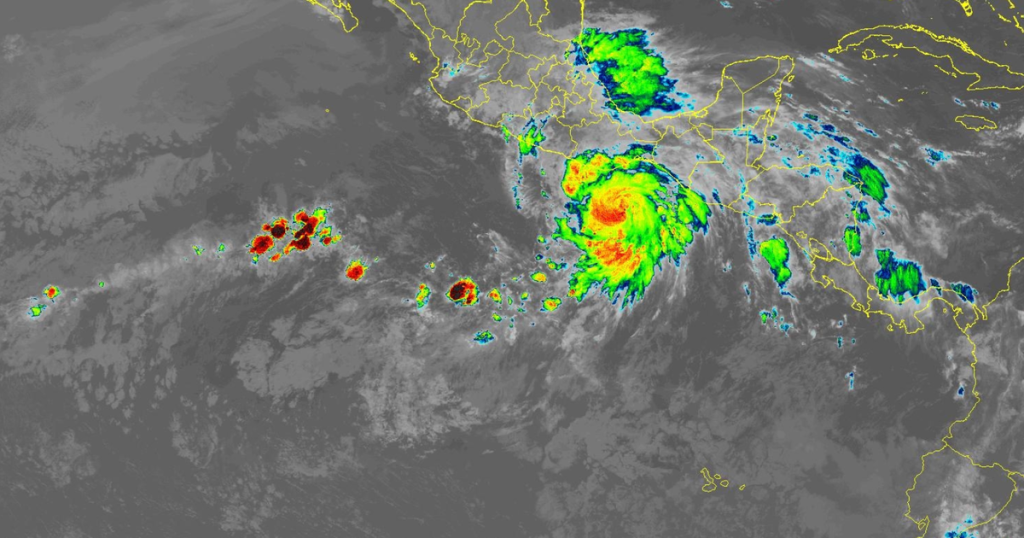
Hurricane Erick, the fifth named storm of this year’s Eastern Pacific hurricane season, is intensifying as it approaches the southern coastline of Mexico. The National Hurricane Center reports that Erick is expected to strengthen rapidly throughout the day and may reach major hurricane status by Thursday. With sustained winds nearing 75 mph and warnings issued for multiple coastal areas, officials are preparing for potentially devastating impacts.
| Article Subheadings |
|---|
| 1) Current Status of Hurricane Erick |
| 2) Forecast for Rainfall and Flooding |
| 3) Warnings and Preparedness |
| 4) Potential Impact of Hurricane Categories |
| 5) Community and Government Response |
Current Status of Hurricane Erick
As of Wednesday morning, Hurricane Erick has demonstrated significant intensification, boasting winds of nearly 75 mph, with even higher gusts recorded. With its center located approximately 15 miles from the coast, the storm is charting a course towards southern Mexico. The National Hurricane Center anticipates that Erick could rapidly ascend to major hurricane strength, defined as a Category 3 or higher on the Saffir-Simpson Wind Scale, before making landfall on Thursday.
Hurricane warnings have been issued for the areas from Acapulco to Puerto Angel, while a hurricane watch extends west of Acapulco to Texpan de Galeana and from east of Puerto Angel to Bahias de Huatulco. This designation underscores the immediate threat and the urgency with which communities along the coast must prepare for the impending storms.
Forecast for Rainfall and Flooding
The anticipated rainfall associated with Hurricane Erick is a major concern, with forecasts indicating totals between 8 and 16 inches across various regions, particularly in the states of Oaxaca and Guerrero. The National Hurricane Center warns that maximum rainfall could reach up to 20 inches, creating life-threatening flooding and mudslides in these areas, particularly those with steep terrain.
Additional rainfall is projected for nearby states, with Chiapas, Michoacán, Colima, and Jalisco expected to experience between 3 and 5 inches of rain. These conditions heighten the risk of hazardous flooding and potential evacuation orders as communities brace for increased water levels.
Warnings and Preparedness
In light of Erick’s trajectory and predicted intensity, local authorities have started initiating emergency protocols. The National Hurricane Center has expanded its warnings to encompass more regions, emphasizing the potential for significant impacts, not only from strong winds but also from storm surge and flooding.
The public has been urged to stay informed through reliable sources, prepare their homes, and have an emergency plan in place. The importance of readiness cannot be overstated, as swift evacuation may be necessary for those in the most vulnerable areas. Government officials are coordinating efforts to ensure that shelters are equipped and ready for citizens needing to leave their homes.
Potential Impact of Hurricane Categories
The Saffir-Simpson Hurricane Wind Scale classifies hurricanes into categories based on sustained wind speeds. While Category 1 and 2 storms can cause damage, it is the higher categories, particularly 3 and above, where the most severe consequences are felt. Major hurricanes have winds ranging from 111 mph to 129 mph, capable of causing catastrophic destruction.
According to NOAA, well-built homes may incur serious damage, including the removal of roof decking and gable ends. The potential for fallen trees and power outages exacerbates the challenges faced by local communities during hurricanes, as many roads may become impassable and basic utilities unavailable for weeks following a storm.
Community and Government Response
In response to the forecasted impact of Hurricane Erick, communities along the affected coastlines have mobilized to address the anticipated dangers. Local governments have been in continuous communication with emergency response teams to deploy resources, including first responders and equipment, to ensure swift action as the storm approaches.
Public safety announcements are being broadcasted across multiple channels to ensure that residents remain informed about storm developments and safety measures. Additionally, community organizations are working to provide support to those who may need assistance during this trying time, particularly vulnerable populations such as the elderly and those without access to transportation.
| No. | Key Points |
|---|---|
| 1 | Hurricane Erick is intensifying as it approaches southern Mexico. |
| 2 | Wind speeds nearing 75 mph have been observed with possible rapid strengthening. |
| 3 | Rainfall totals could reach up to 20 inches, causing severe flooding and mudslides. |
| 4 | Emergency protocols are being implemented as communities prepare for impact. |
| 5 | Local governments are coordinating resources to ensure public safety during the storm. |
Summary
As Hurricane Erick continues its approach towards Mexico, the intensification of the storm poses a significant threat to communities along the coast. With projections of high wind speeds and life-threatening rainfall, officials are urging residents to take immediate action in preparation for the storm. The coordinated effort among local governments and emergency services highlights the seriousness of the situation and underscores the need for public readiness in the face of natural disasters.
Frequently Asked Questions
Question: What category is Hurricane Erick expected to reach?
Hurricane Erick is anticipated to reach major hurricane status, classified as a Category 3 or higher, with sustained winds of at least 111 mph.
Question: What kind of damage can be expected from a major hurricane?
A major hurricane can cause devastating damage, including destruction of buildings, power outages, and fallen trees, which can block roads and disrupt essential services.
Question: How much rainfall is expected from Hurricane Erick?
The National Hurricane Center forecasts that Hurricane Erick could bring rainfall totals ranging from 8 to 20 inches, particularly across the states of Oaxaca and Guerrero, leading to significant flooding risks.
