
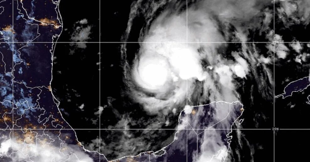
Hurricane Isaias has strengthened from a tropical storm into a hurricane as of late Wednesday night, marking the first hurricane of the 2026 Atlantic season. The storm is projected to make landfall along the U.S. Gulf Coast this weekend, specifically threatening regions in Mississippi, Alabama, and the Florida Panhandle. In response to the impending danger, state officials have declared states of emergency in several affected counties.
| Article Subheadings |
|---|
| 1) Hurricane Isaias Gains Strength and Trajectory |
| 2) State of Emergency Declared in Multiple States |
| 3) Current Weather Warnings and Expectations |
| 4) Historical Context of Hurricane Seasons |
| 5) Future Projections and Weather Patterns |
Hurricane Isaias Gains Strength and Trajectory
The National Hurricane Center reported that Hurricane Isaias has reached maximum sustained winds of 75 mph and is currently located approximately 460 miles southwest of the Mississippi River’s mouth. This transition from a tropical storm to a hurricane occurred late Wednesday night, presenting an increased risk for areas along the Gulf Coast. Forecasters predict that Isaias will make landfall late Friday or early Saturday, transitioning from offshore warm waters to impacting land and potentially inflicting significant damage.
Meteorologists have conveyed concern regarding the speed of Isaias’s winds as it approaches land, indicating a likelihood of strengthening as the system moves through favorable conditions. The hurricane is expected to produce life-threatening weather elements, including heavy rainfall, storm surges, and high winds, potentially leading to hazardous flooding in coastal communities.
State of Emergency Declared in Multiple States
In light of the imminent threat, Florida Governor Ron DeSantis declared a state of emergency for over two dozen counties in Florida, aimed at activating response services and ensuring readiness for the storm’s impact. Alabama’s Governor Kay Ivey has followed suit by issuing a state of emergency for 40 counties, recognizing the necessity for immediate preparation. These declarations facilitate resource allocation and potentially open emergency management facilities for the affected citizens.
These proactive measures are essential to mitigate risks associated with the storm and to provide government assistance as communities brace for the anticipated impacts. As residents in affected areas prepare for worsening weather conditions, local authorities are closely monitoring storm patterns to provide timely updates and guidance.
Current Weather Warnings and Expectations
The National Hurricane Center has issued a hurricane warning for the northern Gulf Coast, extending from Ocean Springs, Mississippi, across Alabama, to the Bay/Gulf County line in Florida. In addition to this, a tropical storm warning has been raised for regions from Louisiana’s Jefferson/Plaquemines Parish line to west of Ocean Springs and from east of the Bay/Gulf County line to Florida’s Aucilla River. Furthermore, a storm surge warning is active from the Mississippi River’s mouth all the way to the Steinhatchee River in Florida, signaling increased coastal flood risks.
Forecasters predict that the rainfall from Isaias may reach between 3 to 7 inches, with some regions possibly receiving as much as 10 inches along the coast from southeastern Louisiana to the Florida Panhandle. These projections suggest that areas farther inland, including parts of the Southeast and reaching to the Tennessee Valley and the Carolinas, may also experience heavy rainfall. This amplified precipitation raises concerns about urban flooding and riverine flooding across affected landscapes.
Historical Context of Hurricane Seasons
The development of Isaias into a hurricane marks the latest occurrence for the first hurricane of the Atlantic season in 121 years. It narrowly misses the record set on October 8, 1905, a point of interest shared by the National Oceanic and Atmospheric Administration (NOAA). The Atlantic hurricane season traditionally spans from June 1 to November 30, and typically, there is an expected average of 14 named storms, with seven classified as hurricanes and approximately three categorized as major hurricanes.
This year’s season has been uncharacteristically quiet, leading experts to note a stark difference in activity levels compared to averages in previous years. The unprecedented delay in hurricane development underscores the influence of climatological factors and shifting ocean temperatures, which have been highlighted throughout the year, leading to lower levels of storm activity.
Future Projections and Weather Patterns
Despite predictions of below-average storm activity for the 2026 Atlantic hurricane season, the unexpected emergence of Hurricane Isaias has sparked renewed interest and concern among meteorologists and residents alike. Factors contributing to this year’s atypical dynamics include the establishment of a strong El Niño, which often correlates with cooler ocean temperatures and greater variance in wind patterns over the Atlantic Ocean—conditions that typically inhibit tropical storm formation and growth. Meanwhile, the Pacific has experienced a succession of active hurricanes.
As the storm progresses, further assessment of the hurricane’s trajectory, wind speed, and potential landfall impacts will continue to shape emergency response actions and community preparedness efforts. State and local officials remain vigilant as monitoring services provide real-time data about Isaias’s intensity and path.
| No. | Key Points |
|---|---|
| 1 | Hurricane Isaias has officially transitioned from a tropical storm to a hurricane with sustained winds of 75 mph. |
| 2 | Emergency declarations have been announced in Florida and Alabama to facilitate storm preparedness efforts. |
| 3 | A variety of weather warnings have been issued, including hurricane, tropical storm, and storm surge warnings across multiple regions. |
| 4 | This season marks the latest first hurricane development in the Atlantic season in over a century. |
| 5 | Future projections indicate less storm activity due to a strong El Niño impacting weather patterns globally. |
Summary
The emergence of Hurricane Isaias represents a significant climatic event for 2026, as it marks the first hurricane of the Atlantic season, with implications for numerous coastal areas in the Gulf of Mexico. State responses highlight the urgency of preparedness amid potentially dangerous weather conditions that could result in severe flooding and infrastructural damage. The unusual timing of this storm development suggests a complex interplay of climatic factors that are contributing to deviations from the historical norms of hurricane activity, warranting ongoing observation and research.
Frequently Asked Questions
Question: What is a hurricane warning?
A hurricane warning indicates that hurricane conditions are expected within a specified area, typically within 36 hours. This alert prompts preparations for potential wind impacts and flooding.
Question: What should residents do during a hurricane?
Residents should secure their homes, prepare emergency kits with essential supplies, and follow directives from local authorities regarding evacuation or sheltering in place. Staying informed through official channels is crucial.
Question: How are hurricanes named?
Hurricanes are named based on predetermined lists created by the World Meteorological Organization, with names being retired after particularly destructive storms to avoid confusion in future seasons.