
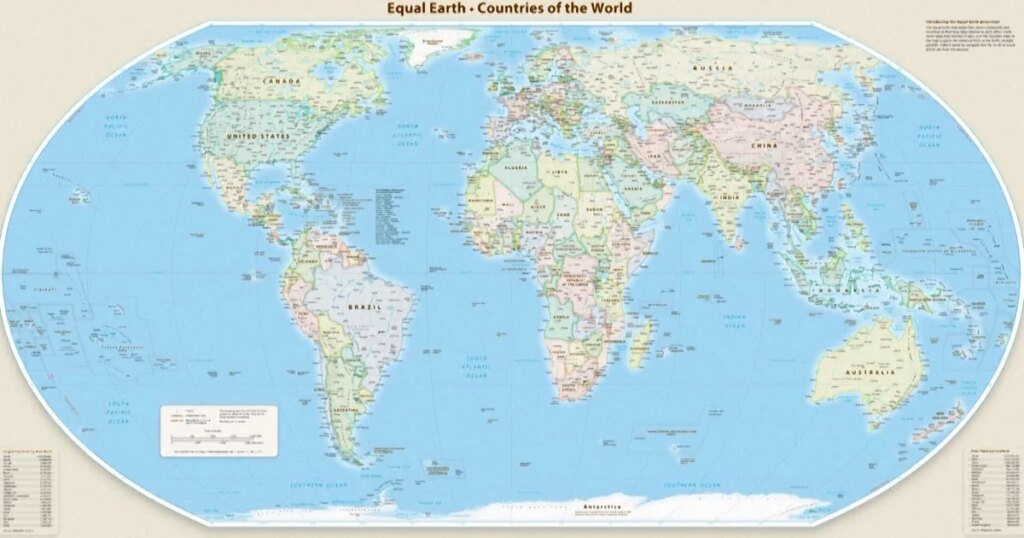
On Friday, the United Nations General Assembly adopted a significant resolution endorsing a new world map that aims to represent Africa more accurately, culminating a dedicated effort by African nations and advocacy groups. The resolution, sponsored by Togo, received overwhelming support, with 164 member states voting in favor while the United States opposed it. The new mapping, termed the Equal Earth projection, challenges the legacy of the traditional Mercator map, suggesting it distorts geographical truths by misrepresenting the size of continents.
| Article Subheadings |
|---|
| 1) The New Resolution and Its Implications |
| 2) Understanding the Equal Earth Projection |
| 3) Historical Context of Map Projections |
| 4) Responses from Global Leaders |
| 5) The Broader Impact of Accurate Mapping |
The New Resolution and Its Implications
The United Nations General Assembly’s recent resolution to endorse the Equal Earth projection represents a landmark shift in how geographical information is perceived and disseminated globally. Sponsored by Togo and strongly supported by various African Union members, the resolution aims to correct misrepresentations inherent in the Mercator map, which has been in use since the 16th century. With 164 member states voting in favor, the measure highlights a collective recognition of the need for equitable representation in global mapping practices.
It is important to note that while the resolution encourages the adoption of the Equal Earth projection, it does not mandate a complete ban on the Mercator map. Instead, it suggests that governments and institutions around the world should begin incorporating the more accurate Equal Earth projection into their geographical depictions. The resolution not only opens conversations about cartography but also addresses a longstanding issue regarding how Africa’s vast size has historically been minimized on maps.
Understanding the Equal Earth Projection
The Equal Earth projection is a modern map type that offers a more accurate representation of landmasses and their sizes. Designed to showcase the Earth’s curved surface accurately, it acknowledges the proportional sizes of continents in a way that traditional maps, like the Mercator, do not. For instance, while the Mercator projection may imply that Greenland and Africa are of comparable sizes, the Equal Earth projection illustrates that Africa is actually 14 times larger than Greenland, better reflecting the geographic reality.
This map’s adoption holds the potential to enhance educational materials, media representations, and public perceptions regarding geographical knowledge. Advocates argue that accurate mapping is vital for informed decision-making, public understanding, and global discourse, affecting everything from end-user applications in ecology to international policies regarding climate change and resource distribution.
Historical Context of Map Projections
Map projections have played a pivotal role in how humanity navigates its world. The Mercator projection, developed by Flemish cartographer Gerardus Mercator in 1569, was initially intended to assist with maritime navigation. However, its reliance on a cylindrical projection means regions closer to the poles, like North America and Greenland, appear significantly larger than they actually are, while regions near the equator, including Africa and South America, are depicted as much smaller. This distortion has lasting implications, affecting geopolitical perceptions and cultural understandings.
The emergence of the Equal Earth projection in 2018 represents an evolution in cartographic science, aiming to rectify historical inaccuracies in map-making. By acknowledging the Earth’s curvature and accurately portraying the size of continents, it seeks to create a more equitable understanding of global geography. Geographers emphasize that while the Mercator projection serves a specific navigational purpose, its broader applications have been misleading.
Responses from Global Leaders
Responses to the U.N. resolution have been varied, with numerous global leaders lauding the initiative while others express reservations. Robert Dussey, Togo’s Foreign Minister, underscored the importance of maps in shaping societal perspectives during discussions leading up to the vote. He remarked,
“Maps shape our understanding of the world. They guide education, nourish the imagination, and influence collective perceptions.”
Countries across Africa applauded the resolution as a step toward correcting historical injustices in representation. French Foreign Minister Jean-Noël Barrot stated via social media after the vote,
“Changing the map obviously doesn’t change the world. But correcting a representation that distorts it is already an act of truth.”
This sentiment reflects a growing acknowledgment of the significance of accurate representations in all areas of life, from education to geopolitics.
The Broader Impact of Accurate Mapping
The endorsement of the Equal Earth projection may extend beyond symbolic gestures towards more meaningful consequences in various sectors. Accurate maps impact education systems, influencing what students learn about geography, history, and global cultures. The call for accurate representations in textbooks and digital platforms emphasizes the necessity of integrating new mapping technologies in educational curriculums worldwide.
Moreover, accurate mapping can transform discussions around international relations, trade, and humanitarian aid. By using accurate representations, countries and organizations can facilitate informed decision-making regarding resource distribution, climate resilience, and urban planning, potentially leading to more equitable global development.
| No. | Key Points |
|---|---|
| 1 | The U.N. endorsed a new map, the Equal Earth projection, to better represent Africa. |
| 2 | 164 member states supported the resolution; the U.S. opposed it. |
| 3 | The resolution encourages adoption of the Equal Earth projection without banning the Mercator map. |
| 4 | The Equal Earth projection claims to depict continents’ true proportions compared to the Mercator map. |
| 5 | Accurate mapping can influence education, international relations, and resource distribution. |
Summary
The recent adoption of the Equal Earth projection by the United Nations marks a pivotal moment in the global understanding of cartography and geographical representation. By recognizing the inaccuracies of the traditional Mercator map, the U.N. drives a narrative aimed at fostering a more equitable depiction of continental sizes, particularly in regard to Africa. The resolution and its implications highlight a growing awareness of the significance of truly representative mapping in education, culture, and international diplomacy.
Frequently Asked Questions
Question: What is the main goal of the Equal Earth projection?
The Equal Earth projection aims to accurately represent the sizes and shapes of continents based on the Earth’s curvature, addressing the distortions present in traditional maps like the Mercator.
Question: Why did the U.S. vote against the resolution?
The U.S. expressed reservations regarding the need for changing existing map projections, emphasizing its commitment to historical cartographic practices while acknowledging the ongoing global discussions about geographical representation.
Question: How can accurate mapping affect education?
Accurate mapping in educational materials can provide students with a more truthful understanding of global geography, history, and cultural dynamics, potentially influencing their perspective on world issues.