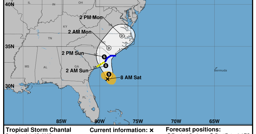
Tropical Storm Chantal has developed off the coast of South Carolina, triggering tropical storm warnings throughout the Carolinas as officials brace for severe weather. Forecasts indicate that Chantal, which has maximum sustained winds of 40 mph, will likely strengthen before making landfall. Meanwhile, the National Oceanic and Atmospheric Administration (NOAA) has projected an above-normal hurricane season in the Atlantic, with up to 19 named storms expected this year.
| Article Subheadings |
|---|
| 1) Formation and Location of Tropical Storm Chantal |
| 2) Forecasted Path and Impact |
| 3) Weather Warnings and Preparedness |
| 4) NOAA’s Prediction for the Hurricane Season |
| 5) Historical Context of Atlantic Hurricane Seasons |
Formation and Location of Tropical Storm Chantal
Tropical Storm Chantal emerged on Saturday morning, approximately 150 miles off the coast of South Carolina. According to the National Weather Service (NWS) in Miami, as of the latest observations, Chantal was effectively positioned south-southeast of Charleston, South Carolina and around 240 miles south-southwest of Wilmington, North Carolina. With maximum sustained winds reaching 40 mph, the storm is moving at a slow pace of about 2 mph.
The formation of Chantal highlights the early activity of the Atlantic hurricane season, which typically starts on June 1 and continues until November 30. Forecasters anticipate that this storm could be an early signal of a more active season ahead.
Forecasted Path and Impact
Predictive models suggest that Chantal will shift northeastward by Sunday night, with the storm center projected to make landfall along the South Carolina coastline. The NWS has warned that additional strengthening is likely to occur prior to impact. For those residing in the affected areas, this is an urgent reminder of the potential for adverse weather conditions.
As the storm approaches, South Carolina’s Emergency Management Division has issued advisories for heavy rain, isolated flash flooding, and gusty winds through Monday. Areas along the coast can also expect rip currents, which pose serious risks to beach-goers. Rainfall totals are anticipated to reach two to four inches in the region, with localized amounts potentially hitting six inches in vulnerable areas.
Weather Warnings and Preparedness
In reaction to the emerging threat posed by Chantal, tropical storm warnings have been established from the South Santee River in South Carolina to Cape Fear, North Carolina. Furthermore, a tropical storm watch has been issued for the segment extending from Edisto Beach to the South Santee River. Authorities urge residents to prepare for possible disruptions, including power outages and heavy rainfall that may lead to flash flooding.
It is crucial for local residents and visitors to remain vigilant and informed. Those in potentially affected areas should assemble emergency kits, secure properties, and heed any evacuation orders issued by local officials. The guidance emphasizes the importance of timely action to protect life and property from unpredictable weather conditions.
NOAA’s Prediction for the Hurricane Season
The National Oceanic and Atmospheric Administration (NOAA) has provided critical predictions for the upcoming Atlantic hurricane season, forecasting a 60% chance of an “above-normal” season. This means that between 13 to 19 named storms are expected. NOAA forecasters anticipate that between six to ten of these storms will develop into hurricanes, while three to five may intensify into major hurricanes.
This forecast serves as a prompt for coastal residents and meteorology professionals to prepare for potential impacts. With increased storm activity, it is imperative to pay attention to local weather alerts and be ready to implement safety measures at a moment’s notice.
Historical Context of Atlantic Hurricane Seasons
The Atlantic hurricane season is notorious for its unpredictability and intensity. Historically, peak hurricane activity occurs from mid-August to mid-October, making this timeframe critical for monitoring storm developments. The 2023 season is poised to mirror past seasons, where prolonged periods of quiet can suddenly give way to multiple storms forming in quick succession.
Residents in hurricane-prone areas are urged to review their emergency plans, especially given NOAA’s projection of a heightened season this year. Understanding past hurricane forecasts and the nature of storm formations can provide valuable insights into the risks and how to prepare effectively.
| No. | Key Points |
|---|---|
| 1 | Tropical Storm Chantal is currently located off the South Carolina coast with winds at 40 mph. |
| 2 | Chantal is expected to make landfall on Sunday night, potentially impacting coastal regions heavily. |
| 3 | Tropical storm warnings are active from South Santee River to Cape Fear, with a watch issued for Edisto Beach. |
| 4 | NOAA predicts a 60% chance of an above-normal hurricane season, with up to 19 storms expected. |
| 5 | Coastal residents are advised to prepare for potential impacts, including floods and power outages. |
Summary
As the Atlantic hurricane season unfolds, Tropical Storm Chantal serves as an early reminder of the potential threats that lie ahead for coastal communities. With looming predictions of an above-normal hurricane season this year, residents must stay informed and prepared to take appropriate action as storms develop. Local governments and emergency management agencies are working diligently to ensure the safety of residents in the affected areas.
Frequently Asked Questions
Question: What should residents do in preparation for tropical storms?
Residents should prepare emergency kits, secure properties, and stay informed about weather updates and local advisories. It’s also important to review evacuation routes and have a plan in place for potential power outages.
Question: How are tropical storms different from hurricanes?
Tropical storms have maximum sustained winds between 39 and 73 mph, while hurricanes have winds of 74 mph or higher. The classification determines the level of preparedness and response required for each type of storm.
Question: When does the Atlantic hurricane season typically peak?
The Atlantic hurricane season typically peaks between mid-August and mid-October, making this period critical for monitoring and preparedness efforts across coastal regions.


