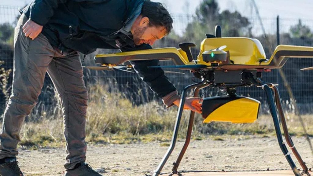
In a groundbreaking advancement in environmental monitoring technology, YellowScan has launched its new Navigator system. This high-tech drone promises to revolutionize underwater mapping, using advanced lidar systems to accurately scan both land and shallow waters. The Navigator addresses significant challenges faced by traditional methods, enabling researchers and conservationists to gather more precise data about our planet’s waterways.
| Article Subheadings |
|---|
| 1) Key features and specifications |
| 2) Environmental applications |
| 3) How the Navigator could transform key sectors |
| 4) Cost of the Navigator |
| 5) Insights from YellowScan’s CEO |
Key features and specifications
The Navigator system, designed by YellowScan, weighs approximately 8.16 pounds, making it suitable for operation with various professional drones. Under optimal conditions, it has the capability to map underwater areas up to 65.6 feet deep, achieving a remarkable accuracy of about 1.18 inches. Some of the key features include:
- Miniaturized high-precision sensor technology that enhances data accuracy.
- Suitability for mapping shallow waters where traditional techniques pose safety hazards.
- Adaptive signal processing that allows functionality in challenging water conditions.
- An integrated camera that provides true-color data visualization.
- Up to 45 minutes of operational autonomy on a single battery charge, which boosts efficiency during assessments.
Environmental applications
The emphasis placed on the Navigator is that it serves as a crucial tool in combatting the impacts of climate change and advancing the field of environmental research. Its capabilities include a variety of applications, as outlined below:
Tracking coastal erosion and sediment movement: The Navigator provides centimeter-level precision in mapping shorelines. This high level of detail allows researchers to model erosion patterns and sediment transport effectively. The data gathered is vital for developing protective strategies for vulnerable coastal communities against flooding and habitat loss.
Monitoring underwater biodiversity habitats: Utilizing its ability to capture detailed 3D images of underwater ecosystems, the Navigator enables scientists to assess both the volume and spatial distribution of aquatic habitats. Such capabilities are particularly beneficial for studying critical environments such as eelgrass beds that support diverse marine life.
Assessing coral reef degradation: The system’s advanced mapping abilities provide researchers with the tools necessary to monitor changes in coral health over time. This information is essential in identifying stress factors, including bleaching events, which directly impact coral ecosystems.
Evaluating sea-level rise impact zones: Precise mapping of low-lying coastal areas at risk from rising sea levels is another significant application. By supplying accurate elevation data, the Navigator aids planners in designing effective mitigation strategies and preparing for potential climate-induced migration.
Documenting changes in marine ecosystems: The advanced lidar technology incorporated in the Navigator captures temporal changes within marine environments, helping to provide insights into how human activity and climate change are influencing the health and stability of aquatic ecosystems.
How the Navigator could transform key sectors
YellowScan accentuates the Navigator’s potential to create significant impacts across various sectors. In the realm of environmental research, it paves the way for enhanced data collection, leading to more accurate environmental assessments. For marine conservation, the Navigator offers advanced tools to better monitor and protect fragile marine ecosystems.
In coastal protection strategies, the system plays an essential role in developing effective measures to combat coastal erosion. The insights garnered from its precise mapping abilities can significantly improve climate migration planning by pinpointing vulnerable areas, thereby enabling more informed decision-making. For infrastructure development, the Navigator aids in efficient planning with its detailed spatial data. Moreover, it opens up new avenues for scientific exploration and helps researchers better understand complex natural environments.
Cost of the Navigator
Though YellowScan has not disclosed the exact pricing for the Navigator, its advanced technology and precision imply that it will require a significant investment. Nevertheless, the long-term benefits—including enhanced efficiency, reduced operational risks, and unparalleled data accuracy—make the Navigator a worthwhile investment for organizations involved in environmental research, infrastructure planning, or marine conservation. Interested parties are encouraged to directly contact YellowScan for tailored pricing information.
Insights from YellowScan’s CEO
In a statement regarding the development of the Navigator, YellowScan CEO Tristan Allouis remarked,
“Years of development and distillation of knowledge were necessary to create YellowScan Navigator. This technology is transforming abstract climate change discussions into concrete, measurable data.”
Summary
The launch of the YellowScan Navigator marks a significant innovation in the field of environmental monitoring. By offering unprecedented precision in mapping underwater topography, the system not only aids researchers in understanding hydrological changes but also plays a crucial role in implementing effective strategies for environmental conservation and climate change mitigation. The versatility of the Navigator ensures its relevance across diverse sectors, exemplifying the demand for advanced technological solutions in navigating the challenges presented by climate change.
| No. | Key Points |
|---|---|
| 1 | YellowScan’s new Navigator drone utilizes advanced lidar technology for precise underwater mapping. |
| 2 | The system can map shallow waters up to 65.6 feet deep with an accuracy of 1.18 inches. |
| 3 | Applications of the Navigator include tracking coastal erosion, monitoring biodiversity, assessing coral reef health, and evaluating sea-level rise impact zones. |
| 4 | The technology enhances environmental research data collection and supports better planning in infrastructure and conservation efforts. |
| 5 | While pricing for the Navigator has not been disclosed, its long-term benefits make it a potential investment for various organizations. |
Frequently Asked Questions
Question: What technology does the Navigator use for mapping?
The Navigator uses advanced lidar technology that enhances the precision of underwater mapping by capturing detailed 3D images.
Question: How deep can the Navigator map underwater terrains?
The Navigator can map underwater areas up to 65.6 feet deep under optimal conditions.
Question: What sectors can benefit from the Navigator’s capabilities?
Sectors such as environmental research, coastal protection, marine conservation, infrastructure planning, and scientific exploration can benefit significantly from the Navigator’s capabilities.


