

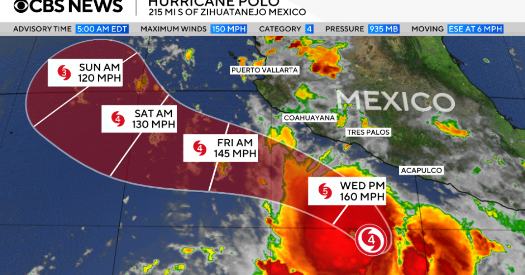

As Hurricane Polo intensifies in the Pacific, it has officially reached Category 5 status, marking it as a significant threat to the southwestern coast of Mexico. With maximum sustained winds clocked at 165 mph, officials have warned that the storm could lead to severe flooding and mudslides particularly affecting the already vulnerable regions of Guerrero and Michoacán. The U.S. National Hurricane Center has labeled Polo as “extremely dangerous” and is closely monitoring its trajectory as it is expected to remain offshore while exerting influence on coastal conditions.
| Article Subheadings |
|---|
| 1) Overview of Hurricane Polo’s Intensity and Path |
| 2) Location and Forecast for Affected Areas |
| 3) Government Advisories and Safety Measures |
| 4) Anticipated Weather Conditions |
| 5) Future Projections and Implications |
Overview of Hurricane Polo’s Intensity and Path
Hurricane Polo rose sharply in intensity on Tuesday, officially becoming a Category 5 hurricane as defined by the Saffir-Simpson Hurricane Wind Scale. This classification is given to hurricanes exhibiting sustained winds of 157 mph or higher, highlighting the potential for catastrophic damage. The U.S. National Hurricane Center has issued strong warnings regarding the hurricane’s capacity to wreak havoc due to its power, which is evident in its maximum sustained winds that reached an alarming 165 mph.
In terms of its movement, Polo has maintained a position offshore while inching northward along the Pacific coast since the morning hours. The hurricane’s trajectory places it near the resort cities of Zihuatanejo in Guerrero and Manzanillo in Colima. According to meteorologists, Polo is expected to undergo fluctuations in strength but will consistently remain a major hurricane in the coming days.
Reports indicate that while Polo’s position is mostly stationary, the storm has begun to release hurricane-force winds that extend approximately 35 miles from its center. This foreboding expansion raises concerns about various coastal locations as they brace for impact.
Location and Forecast for Affected Areas
As of Tuesday evening, Hurricane Polo was closely monitored by meteorological agencies situated near the coasts of Zihuatanejo and Manzanillo. The hurricane’s forecast indicates it will soon bring tropical storm conditions to the adjacent coastlines starting Wednesday morning, as heavy rainfall is expected to inundate the region.
The U.S. National Hurricane Center has particularly specified that areas in Guerrero and Michoacán may expect between 4 to 8 inches of rain through Thursday, with some regions potentially experiencing up to 8 inches. The threat of flooding looms large, especially in areas characterized by steep terrain, as heavy downpours could trigger significant mudslides.
Moreover, forecasters have expressed concerns about the repercussions of storm surge, which may lead to the inundation of low-lying coastal areas. Residents and visitors in these regions are urged to remain vigilant as the storm continues to develop.
Government Advisories and Safety Measures
In response to the threatening hurricane, the Mexican government has issued a tropical storm warning covering a stretch of coast from Tecpan de Galeana in Guerrero to Punta San Telmo in Michoacán. A tropical storm watch is also officially in effect for Punta San Telmo stretching to Playa Perula in Jalisco. The warning states that the onset of tropical storm conditions is imminent, advising residents to prepare accordingly.
The difference between a tropical storm warning and a watch is significant. Warnings indicate that tropical storm conditions are expected, while watches signify that conditions could arise but are not yet certain. Local authorities have emphasized the importance of being prepared for possible evacuations and remain on high alert as Polo advances closer to land.
People in the region are encouraged to secure outdoor belongings, stock up on emergency supplies, and adhere closely to guidance provided by local officials and emergency services personnel to ensure their safety during this precarious time.
Anticipated Weather Conditions
In conjunction with significant rainfall, meteorologists forecast that Polo will create hazardous surf conditions along the southwestern coast of Mexico. These conditions will dramatically enhance the risk of rip currents, posing dangers to swimmers and beachgoers trying to navigate the rough waters.
Tropical storm conditions that are expected to commence by Wednesday could really escalate in severity. While the worst of the storm may be centered offshore, the peripheral conditions alone are enough to severely impact coastal communities through flooding and treacherous waves. Reports suggest that residents should remain indoors, especially during the storm’s peak intensity.
The National Hurricane Center has continuously provided updates regarding storm movements and conditions, allowing those in affected areas to stay informed and plan accordingly. Communities that historically face the brunt of such storms should activate their preparedness plans to mitigate potential damage and enhance safety measures.
Future Projections and Implications
Looking ahead, forecasts indicate that Hurricane Polo may alter its course and make a sharp turn northwestward within the next 24 hours. This trajectory could significantly impact the southwestern coast of Mexico as the core of the storm may approach these critical areas sooner than initially anticipated.
As the storm nears landfall, the situation is being monitored closely by meteorologists, who emphasize the need for communities to remain alert and prepared for the potential arrival of dangerous weather. The implications of such a powerful hurricane can be far-reaching, affecting not just immediate coastal cities, but also inland areas that may experience catastrophic flooding as rainwater accumulates.
The upcoming days will be crucial, as the storm maintains its intensity while inching closer to the mainland, causing officials to implement ongoing assessments and necessary adjustments in emergency preparedness measures.
| No. | Key Points |
|---|---|
| 1 | Hurricane Polo has rapidly intensified to a Category 5 storm with sustained winds of up to 165 mph. |
| 2 | Areas of Guerrero and Michoacán are under warning for heavy rainfall and potential flooding. |
| 3 | The Mexican government has issued tropical storm warnings and watches along the coastline. |
| 4 | Hazardous surf conditions are expected along the southwestern Mexican coast, including rip currents. |
| 5 | Projections indicate that Polo may take a northwest turn, approaching the coastline in the upcoming days. |
Summary
The intensifying Hurricane Polo poses a severe threat to the southwestern coast of Mexico, raising alarms for potential flooding and mudslides in the targeted regions. With government advisories in place and a serious forecast of hazardous conditions, both residents and officials are bracing for impact. As the hurricane continues its dramatic path, it highlights the relentless power of nature and underlines the critical importance of timely warnings and preparedness in safeguarding communities.
Frequently Asked Questions
Question: What criteria classify hurricanes into categories?
Hurricanes are classified into categories based on their sustained wind speeds using the Saffir-Simpson Hurricane Wind Scale, with Category 1 representing the lowest wind speeds and Category 5 representing the most severe.
Question: What measures should residents take before a hurricane hits?
Residents should secure their homes, stock up on essential supplies like food, water, and medications, and follow guidelines provided by local authorities regarding evacuations and safety protocols.
Question: How can heavy rain from a hurricane lead to flooding?
Heavy rainfall can overwhelm drainage systems and lead to rapid accumulation of water in low-lying areas, causing floods that can be particularly dangerous, especially in steep or unstable terrains.
