

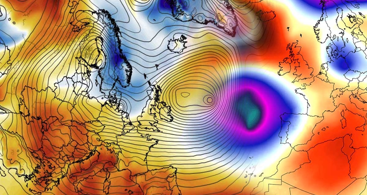

Severe storms originating from the North Atlantic are poised to impact a vast area across Europe, stretching from the west to the southeast. Heavy rainfall is forecasted, particularly affecting Southeastern Europe and the Balkans, including Türkiye, where localized precipitation may surpass 300 millimeters. This alarming situation raises concerns regarding potential floods and landslides across critical regions such as France, the Alps, and the broader Balkan area.
A significant low-pressure system has emerged over the North Atlantic, churning strong westerly winds toward Europe. This system is facilitating the influx of humid air, resulting in successive rainfall events expected to persist for the following week.
| Article Subheadings |
|---|
| 1) Anticipation of Heavy Rainfall in the Balkans |
| 2) Türkiye Braces for Severe Weather |
| 3) Impact of Rainy Weather in Southeastern Europe |
| 4) Rising Temperatures Across Europe |
| 5) Snow Forecast in Scandinavia |
Anticipation of Heavy Rainfall in the Balkans
Meteorological predictions indicate that the southeastern regions of Europe, specifically the Balkans, will undergo severe weather conditions as humid air from the Atlantic brings heavy rains. Rainfall is expected to peak in areas such as Slovenia, Croatia, Bosnia and Herzegovina, Montenegro, and Albania, with local amounts potentially exceeding 300 millimeters. This level of precipitation within a brief time frame poses serious risks, including flooding and landslides, particularly in mountainous regions where the topography amplifies runoff.
Authorities have issued warnings to residents in these zones to be prepared for extreme weather conditions, as the infrastructure may not withstand the sudden onslaught of rain. Meteorologists are closely monitoring the situation, as the intensity of rainfall may vary within localized areas, increasing the potential for disasters. The urgency of preparedness is amplified by the forecast suggesting that these rainfall events could begin as early as the weekend and last for several days.
Türkiye Braces for Severe Weather
As the active weather systems shift toward Europe, Türkiye is also expected to experience significant rainfall and wind, particularly between November 18 and 24. The General Directorate of Meteorology has predicted widespread showers across the country, with specific forecasts indicating storm-force winds reaching between 50-80 kilometers per hour in the Marmara region on November 18 and intensifying rainfall from the following day.
Regions including the Black Sea coast, as well as areas in southern Türkiye such as Adana and Tunceli, are likely to see a marked increase in precipitation. Expected rainfall will vary, but rainy weather will prevail in several major areas across the Marmara and Southeastern Anatolia through November 22. Although Türkiye is anticipating storms, it remains unclear to what extent the precipitation is directly related to the North Atlantic low-pressure system, necessitating further meteorological analysis.
Impact of Rainy Weather in Southeastern Europe
The incoming Atlantic rain systems are also expected to strengthen their influence in Southeast Europe, particularly the Western Balkans. As these weather patterns evolve, Southeastern Europe, including Türkiye, will witness increasing rainfall, reinforcing concerns related to flooding and landslides in vulnerable areas. Current forecasts do not provide a definitive rainfall accumulation or storm prediction for Türkiye, but the ongoing weather activity suggests heightened vigilance is necessary.
Communities are advised to stay informed through official weather channels, as the situation may develop rapidly. Local governments have started preparing crisis management measures to mitigate risks associated with heavy rainfall, focusing efforts on regions expected to bear the brunt of the bad weather. The high vulnerability of infrastructure in these areas underscores the importance of timely communication between meteorological agencies and local authorities.
Rising Temperatures Across Europe
Despite the impending storms, the weather systems moving through Western and Central Europe are also introducing mild and humid air. This phenomenon is likely to result in above-average temperatures in Southern and Central Europe, with various regions potentially experiencing temperatures 8-12 degrees warmer than seasonal norms.
For instance, regions across Italy and the Balkans are projected to enjoy relatively mild temperatures, reaching between 15-20 degrees during the day. This unexpected warmth could lead to an increased risk of flooding, as warmer conditions may accelerate the melting of remaining snowpack and prompt higher runoff into rivers and waterways.
Snow Forecast in Scandinavia
While Southern and Western Europe contends with rain, the northern regions of Scandinavia are gearing up for significant snowfall. Meteorologists predict that snow depth could exceed 50-75 centimeters over the next week in central and northern Norway, along with parts of Finland and Sweden. This snow is expected mostly in the Alps, particularly in high-altitude zones, as the storm interacts with existing weather patterns.
As the weather system progresses, it will be crucial for meteorological services in Scandinavia to monitor snow accumulation closely. Heavy snowfall poses risks for travel and infrastructure but also provides much-needed water resources for the regions’ ecosystems and hydropower production as temperatures eventually stabilize.
In summary, while Europe braces for mixed weather conditions, ranging from torrential rains in the south to profound snowfall in the north, preparedness at multiple levels—government, community, and individual—remains essential in mitigating the impact of these extreme weather events.
| No. | Key Points |
|---|---|
| 1 | Severe storms from the North Atlantic are impacting Europe, particularly Southeastern Europe and the Balkans. |
| 2 | Rainfall amounts may exceed 300 millimeters in regions of the Balkans, raising flood concerns. |
| 3 | Türkiye is expected to experience heavy rainfall, with storm-force winds advised for several regions. |
| 4 | Temperatures in Southern and Central Europe are anticipated to rise above normal averages. |
| 5 | Scandinavian regions may see significant snowfall, with snow depths expected to exceed 75 centimeters. |
Summary
In conclusion, Europe is poised to experience a series of weather extremes influenced by a potent North Atlantic low-pressure system. Flood risks loom large in the Balkans and Southeastern Europe, while a contrast of mild temperatures is likely across other areas. The mixture of heavy rains and significant snowfall presents a dual threat across the continent, underscores the urgent need for preparedness and proactive communication among authorities to safeguard life and property as the situation develops.
Frequently Asked Questions
Question: What weather patterns are currently affecting Europe?
Europe is facing a significant weather disturbance emanating from the North Atlantic, characterized by strong storms that bring heavy rainfall, particularly to Southeastern Europe and the Balkans, while the north experiences substantial snowfall.
Question: How much rainfall is expected in the Balkans?
Localized rainfall in the Balkans is expected to exceed 300 millimeters in some mountainous areas, which poses a serious risk of flooding and landslides.
Question: What preparations are being made in Türkiye in response to the expected rainfall?
Authorities in Türkiye are preparing for widespread showers and storms, with local governments taking precautions to minimize risks related to flooding and managing emergency responses.
